Day 1: Greeting at Tribhuvan International Airport (Transfer to Hotel)
Our Speedy Tourism and Travel member will meet you at the airport and exchange to your inn. As you spruce up after your long voyage, you will be approached to visit our office for instruction on your program. You will have a gathering with your trekking guide and talk about the equipment required for the trekking and we will process for the trekking permits. If you arrive around evening time, we will have a similar discussion in the next day morning.
Day2: A full day recreational tour of Kathmandu
The exceptionally next morning, after breakfast you will be taken for an entire day touring visit around Kathmandu valley. You can visit the focal point of pilgrimage Pashupatinath Temple and Swyambhunath, exceptionally ancient and basically enrolled in UNESCO World Heritage sites. The greatest Buddhist Stupa at Boudhanath may make you feel quiet and harmony and visit Patan the city of expressive arts and Durbar Square is brimming with Hindu sanctuaries and Buddhist landmarks. On an adventure back to the lodging, you can investigate the neighborhoods and way of life. After your supper, you can maybe go for a relaxed walk through the well-known streets like Thamel and Durbarmarg.
Day 3: Kathmandu Drive to Soti Khola (710m) 8hrs Drive
Today we will have an 8-hour driving journey to Soti Khola. You drive along the Kathmandu-Pokhara Highway for the initial segment of the day till Dhading Bensi. From Kathmandu to Dhading Bensi (District headquarter of Dhading 1050m) for 4 hours is comfortable to drive and from that point to Arughat for an additional 4 hours, we will drive on the rough road with beautiful perspective on scene, villages, river, Mt Ganesh Himal and Manaslu. Overnight remain at the nearby guest house.
Day 4: Soti Khola Trekking to LabuBesi (880m)
The trail crosses the bridges and treks through the wonderful Sal forests, at that point ascends onto an edge over the Budhi Gandaki and pursues a way impacted out of vertical rock to Khorsane (820m). The course gets somewhat shaky as it ignores a big rock and crosses a stream. A few pieces of the trail are especially extreme and chances of landslides and require additional consideration particularly when donkeys are near. The trail, in the end, makes it path down and past a couple of rice terraces on a precarious rough trail and down then up around to the Gurung Village of LabuBesi.
Day 5: LabuBesi to Doban (1000m)
The path moves behind a rocky outcrop. The trail makes some minor ups and down. Dropping to the sandy waterway bed at 860m from LabuBesi and moving about 110m over a side edge to convey you to Maccha Khola town (900m). Crossing Tharo Khola reaches to Khorlabesi and moving over a little edge, make another lofty climbing, the routes come to Tatopani (930m), which signifies 'hot water'. From the hot spring, the trail moves over another edge and crosses the Budhi Gandaki and trips on a wide, very much made staircase over an edge to Doban.
Day 6: Doban Trek to Jagat (1410m)
A large bridge conveys the trail over the Doban Khola. The routes remain low at first and afterward gets on a tough rough trail to Duman. Crossing a 93m long bridge over the Yaru Khola (1330m) and climbing some stone stairs you reach to Tharo Bharyang. Trekking along the stream for some time and moving through a small village, you get to Jagat which is a delightful flag stone village. There is a decent campground around the local area and another beneath the village by the Bhalu Khola.
Day 7: Jagat Trekking to Ngyak Bensi (2300m)
Climb over a rough edge to Salleri (1440m) where you have great perspectives on Sringi Himal. The trail slightly descents to Setibas (1430m) and after that, the valley extends a bit as the trail proceeds up to the stone places of Ghatta Khola. From here you can see Mt. Lapuchun (5,950m).
Day 8: Ngyak Besi Trekking to Ghap
The trail descends with green slants dabbed with tall pine trees. The trek takes us through a vigorously forested region in a thin valley, offering a lovely walk through bamboo forests and a collection of rocks as we achieve the little settlement of Deng (1800m). A short distance past Deng crossing the Budhi Gandaki River, the trail climbs to Rana (1980m). Subsequent to passing a few houses the trail moves high over the river and drops into the Sringi valley. The trail makes further ups and down through the forests giving us perspectives on the Manaslu Massif before reaching to Ghap.
Day 9: Ghap Trekking to Namrung (2660m)
Pass a few of houses and three streams in a forest of enormous fir alive with birds including Danphe (national fowl of Nepal). The trails make a genuine and long move through bamboo and rhododendron forests crossing the river a few times. The trail crosses the Budhi Gandaki twice on wooden bridges before entering Namrung. Namrung is a Buddhist town where there are monasteries, a water turbine, hydropower control house, Mani walls.
Day 10: Namrung Trek to Samagaon (3530m)
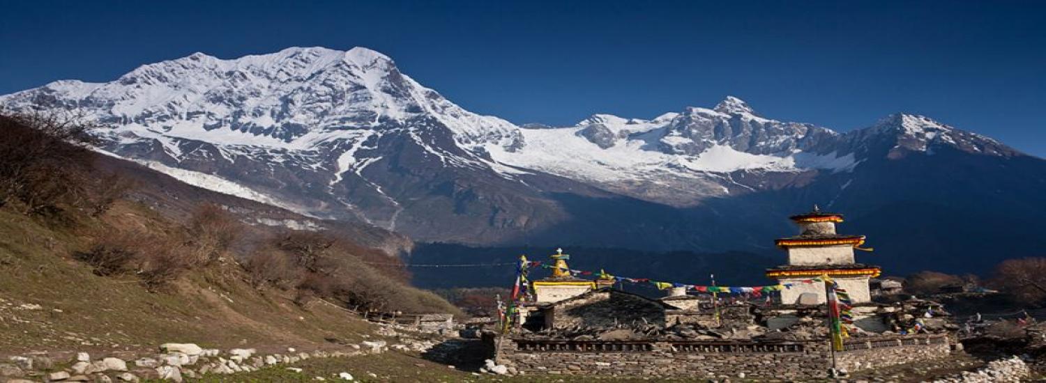
You trek over a winding way which travels through the inward Himalayan range getting a charge out of mountain perspectives on Rupina la pass, Mt. Manaslu, Gorkha Himal, Dwijen Himal, Saula Himal, Lajing top, and numerous other snow-topped mountains and pinnacles. Moving through the forest of firs, rhododendrons, and oaks the trail goes into the firmly stuffed places of Lihi (2900m) and a few Buddhist villages in the route. These regions have been affected by the Tibetan culture because of its nearness to Tibet, and subsequently, you will discover numerous religious communities and Mani-dividers. From Samagaon you can see Mt. Manaslu and the Kutang Himal Massif.
Day 11: Samagaon Trekking to Samdo (3860m)
You trek slightly descends all the way to Samdo through a desert way and windy valley. From Kargyu Chholing Gompa the course passes the juniper and birch timberland and the stone cabin of Kermo Kharka. It climbs bit by bit towards Samdo, and just before entering the town goes through the point where the Budhi Gandaki really begins – at the conversion of Larke Khola and the waterway originating from Samdo Glacier. Samdo is the site of a Tibetan displaced person camp and bears you an uncommon look into the way of life of the Tibetan individuals. This is a superb viewpoint for Mt. Manaslu, Samdo (Pang phuchuli), Nagdi chuli, Simnang Himal, Manaslu icy mass, Manaslu icefall and a few other grand peals. Stay at the nearby guest house.
Day 12: Sambo to Dharamsala/Larkya Rest house (4480m)
Descend on a wide, delicate trail from Samdo past numerous fields to an extensive Mani divider and stone archway. The trail is rough and crisscrosses the whole distance to your goal. The roaring Budi Gandaki streams to a stream as we keep on following its route at any point upwards encompassed by fabulous mountains from all sides. In the wake of the intersection toward the east bank of the stream, we achieve the last permanent settlement in the valley, which is called Sumdu. Over the village, we cross the stream, which keeps running down from the Gya La (Pass), the go-to Tibet. We go to the remnants of a surrendered town, known as Larkya Bazaar. The trail ascends high over the Larke Khola driving the whole distance to Dharamshala where the trail at long last meets the river.
Day 13: Dharamshala to Bimtang (3720m)
The trail becomes rougher as it comes to a moraine and achieves a wonderful turquoise lake that mirrors the encompassing cold mountains. The trail turns out to be to some degree repetitive as it jumps on various rough moraines slopes encompassed by rough slopes and frigid edges past. This is an increasingly strenuous day as the need to traverse the Larkya Pass (5213m). The trail at that point ends up steady as it comes the moraine and parallel to Bimtang ice sheet towards Bimtang. From here, you may see perspectives on Himlung Himal (7126m), Cheo Himal (6820m), Gyaji Kung (7030m), Kang Guru (6981m) and Annapurna II (7937m).
Day 14: Bimtang to Tilje
The trail descends from Bimtang and crosses a glacial stream, the headwater of Dudh Khola on a wooden bridge. Make a slight descent through rhododendron and pine forest seeing the north substance of Manaslu along the route. You achieve the most elevated developed land in this valley of Karche at 2785m and strolling down you cross a stream through fig tree and rhododendron forests to reach Tilje. We will make camp in the apple plantations of Tilje.
Day 15: Tilje to Tal (1700m)
Crossing this high field, you descend slightly from the Burdin Khola to the territory of the Base Camp for the West side of Manaslu. You trek the whole distance over a slid way along the bank of Dudh Khola (stream) and Marsyangdi River. Another scaffold takes you over the Marsyangdi River to Dharapani (1920m), where you join the Annapurna traveler highway and begin missing in Manaslu where you had Nepal practically all to yourself. It takes a large portion of multi-day to proceed to Tal where the river shows up as a lake and make camp beside a waterfall going down the Marsyangdi river trail.
Day 16: Tal drive to Kathmandu
The down piece of the trail has road now so we can take a low jeep or bus to Besisahar and from there transport to Kathmandu, we can remain overnight at Besisahar and can drive to Kathmandu additionally next day.
Day 12: Final Departure
We will drop you at the Tribhuvan International Airport (TIA) for your voyage back to your home.